Hill climbs selected local to the start of the Wigmore Cycling Clubs Sunday ride, all within 15 km. These are only fun challenges. Please monitor yourselves and observe all traffic codes. Keep safe and no posthumous prizes will be awarded.
Climbs to be on a bicycle and must be recorded on Strava to collect activity data with visibility open to all to allow WCC to collate results and provide updates during the year.
Click on the name of the hill to open a link to the Strava segment in a different tab.
| Hill number | Strava Name | Location | Height Gain (m) | Route Length (km) | Max Gradient | Average Gradient |
|---|---|---|---|---|---|---|
| 1 | Chatham Hill (railway bridge to bus lights) | From the east side of Rainham A2 onto Mierscourt Road south. | 65 | 0.92 | 5.30% | 7.00% |
| 2 | Birling Hill Full but also cover the shirt version. | From Birling to the top of the Downs | 151 | 2.54 | 16.20% | 5.90% |
| 3 | Scragged Oak (Full Climb) | From the west end of Queendown Warren towards showground. | 99 | 3.15 | 10.60% | 3.10% |
| 4 | Gallent Lane (Full) | Between East Farleigh & Kettle Corner, Gallent Lane climb south. | 81 | 1.76 | 12.90% | 4.60% |
| 5 | Cliffe Road | Strood leave north on Frindsbury Road 2nd left target Broomhill. | 43 | 0.74 | 7.20% | 5.70% |
| 6 | Frinstead Climb | South of Sittingbourne to Frinstead. | 73 | 1.47 | 17.10% | 4.90% |
| 7 | Cobhambry Road | From the Bush Road Cuxton upwards to Cobham. | 71 | 1.53 | 12.40% | 4.50% |
| 8 | Climb up Capstone Road towards Lidsing | Base of Ash Tree Lane the length of Capstone Road. | 71 | 2.93 | 11.00% | 2.40% |
| 9 | Cold Blow Lane, Thurnham | From Pilgrims way between Detling and Hollingbourne. | 94 | 0.92 | 20.10% | 10.30% |
| 10 | Faversham Road Uphill | From the A20 in Lenham north steep after the dog leg. | 65 | 1.12 | 11.20% | 6.00% |
| 11 | Boxley Road Climb, Walderslade | Robin Hood Lane base, the Sherwood Oak pub south and up. | 61 | 1.88 | 7.40% | 3.20% |
| 12 | Warren Lane | Hartlip to Queendown Warren | 61 | 1.87 | 10.40% | 2.80% |
| 13 | Straight Hill Stockbury | Queendown Warren along Cradles Road to Stockbury. | 58 | 0.92 | 9.40% | 6.10% |
| 14 | South Green Climb | From south bound A249 to South Green | 53 | 1.52 | 10.80% | 4.10% |
| 15 | Col de Rue d'Ecole | Wouldham, to become popular with the one-way system. | 48 | 0.85 | 12.00% | 5.70% |
2024 Hill Climb Competition locations

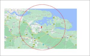
The red circle identifies the area at a radius of 15 km from Rainham.
The 15 hills selected for the 2024 challenge are within this circle and are all existing Strava segments.
All WCC members are welcome to take part and either send their results to Scorekeeper@wcc.bike or save the activity in Strava with “visibilty all” to permit result data to be collected.
Map
Here is a map showing the start and finish of each of the climbs, click here.
Routes
Here are some routes that include all the climbs (but feel free to create your own):
ROUTE 1: Garmin route to reach Hills; 15 (Col de Rue d’Ecole) , 2 (Birling Hill), 7 (Cobhambry Road, down) and 5 (Cliffe Road):
https://connect.garmin.com/modern/course/230735745
35 miles
ROUTE 2: Garmin route to reach Hills; No 12 (Warren Lane, down), No 13 (Straight Hill Stockbury), No 14 (South Green Climb) and No 6 (Frinstead Climb)
https://connect.garmin.com/modern/course/232962801
25 miles
ROUTE 3: Garmin route to reach Hills; No 3 (Scragged Oak), No 9 (Cold Blow Lane) and No 9 (Faversham Road).
https://connect.garmin.com/modern/course/232967630
38 miles
ROUTE 4: Garmin route to reach Hills; No 1 (Chatham Hill), No 8 (Capstone Road) No 4 (Gallant Lane) and No 11 (Boxley Road, down).
https://connect.garmin.com/modern/course/232999809
36 miles

